The story of 290 souls moved from Mt. Zion AME to the Roberts Burial Ground along W DeKalb Pike, near the intersection of Route 202 and Town Center Road.


The story of 290 souls moved from Mt. Zion AME to the Roberts Burial Ground along W DeKalb Pike, near the intersection of Route 202 and Town Center Road.
Transportation continued to be an integral part of Upper Merion’s development in the early 1900s. Beginning life as the Philadelphia & Western Railroad, a standard-gauge electric interurban transit system was originally projected to extend much further west. The original line was built from 69th Street to Strafford in 1907, to compete with the Pennsylvania Railroad’s suburban local service. A branch from Villanova Junction to Norristown was added in 1912, and it turned out to be more important than the “main line” to Strafford, which was never extended further.
This extension changed the geography once again. The transit line would pass through Upper Merion with three stations. Taking advantage of geography, the train left grade and ran on a high embankment at the Matsonford stop. The train continued on a shelf above the highway and then took a gentle “S” curve, before calling at the Gulph Mills stop. After Gulph Mills, the line was back to grade and the cars entered the speedway portion of the line, almost all straight through to King Manor.
As the area around the village of King Manor developed, the King Manor Station was also a busy stop. From here, the line travelled through Bridgeport and onto Norristown. This new line was a unique line which had the elements of heavy rail, light rail, and commuter rail all wrapped into one. It had the high-level platforms and third-rail contact typical of heavy rail lines, with the closely-spaced stops, on-board fare collection, and generally a single-car operation found on light rail lines, with the general peak direction traffic and suburban setting associated with commuter rail.
At Norristown, the P&W connected with another interurban line, the Lehigh Valley Transit, which operated through service between 69th Street and Allentown.
Over the years, the line became faster and more famous. In 1931, Brill Bullet cars were purchased. This increased the travel speed of the line immensely. The Brill Bullets were famous, as they were the first railcars designed in a wind tunnel. For almost 60 years these cars, along with the Strafford cars that also ran along the line, served the P&W, which later became a part of the Red Arrow Lines and finally the SEPTA Route 100 line.


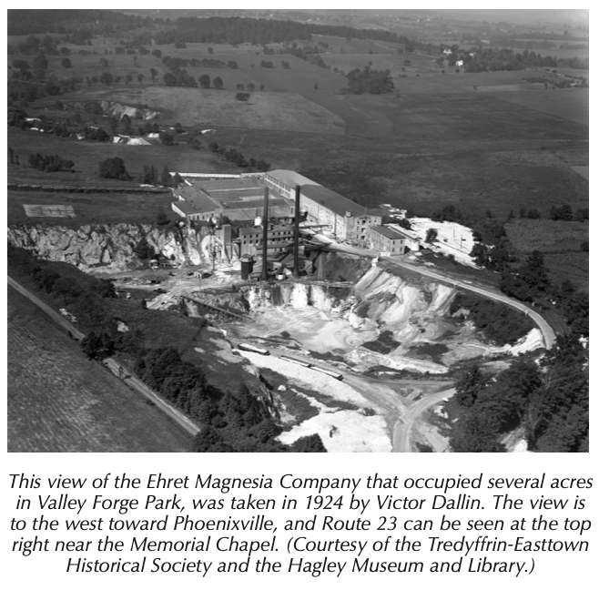
The manufacture of magnesia products was another use for the dolomitic limestone of the Great Valley. This is calcium magnesium carbonate, not the calcium carbonate of normal limestone. Between … 1877 and the construction of their first buildings in 1895, the Ehret Magnesia Manufacturing Company started buying up and consolidating many of the smaller Port Kennedy quarries. … the magnesium content—carbonate of magnesia—of Port Kennedy limestone was as high as 42% (vol. 1, p. 26)—very high.
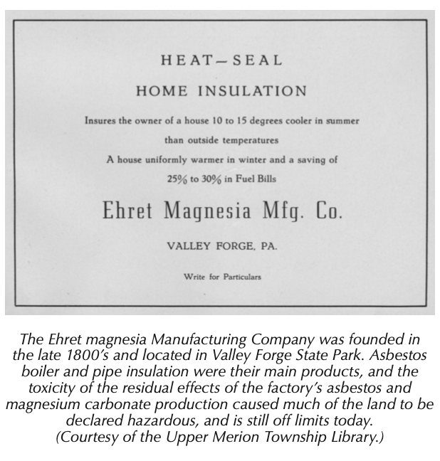
Asbestos is a naturally occurring mineral silicate with strong white fibers. The insulating and flame retardant qualities of asbestos were known as far back as ancient Rome and by the Industrial Revolution at the end of the 1800s, asbestos was used in the manufacture of thousands of products. By the 1970s the health hazards of asbestos had become known.
This was what Ehret was manufacturing in Valley Forge. They specialized in what were called 85% magnesia products—insulating pipe covers, insulating blocks, and felt fiber. The 85% was the magnesia; the other 15% was the mineral silicates—the stuff that causes asbestosis and mesothelioma. Over the course of its 80-year history in Valley Forge, Ehret built 20 buildings.
… During World War I Ehret was manufacturing insulation products the U.S. Navy needed at the same time the park was planning to acquire—by demolition—land on which plant workers’ houses stood. The commission delayed its plans in support of the war effort. After the war, Ehret planned to spend $100,000 to build new workers’ housing and make other improvements to its plant site next to the park. Ehret refused to cooperate when the park commission resumed its demolition of workers’ houses and the commission retaliated by declaring Ehret’s new proposed housing tract a future part of the park…
… As the company grew, its name was changed to the Baldwin-Hill Company, in 1959 to Baldwin-Ehret-Hill, Inc., and some time in the 1960s or early 1970s it was purchased by the Keene Corporation, a Fortune 500 company. By that time the plant was completely surrounded by land owned by the park. Keene continued manufacturing insulating pipe covers and blocks, felt products, and insulating cement. Between 1925 and the early 1970s Ehret and its successors disposed of waste products from manufacturing operations directly into the Schuylkill River and through a slurry pipeline into several of the inactive limestone quarries.
… in 1975 the U.S. Department of the Interior recommended that the Keene property be purchased and gave an estimated cost of $3,878,450 (p. 559). The plant was closed in 1976 and the rail spur was abandoned. On October 13, 1976 the National Park Service purchased the 46-acre Keene property and the asbestos manufacturing plant. The site had been heavily vandalized and the park razed several of the buildings in 1978.
… In January 1997, while installing underground fiberoptic cable in the amphitheater area, the park discovered asbestos in the soil. The U.S. Environmental Protection Agency was brought in and between May and October of 1997 emergency response action was taken to abate immediate risks to public health and the environment in all quarry and related areas. All quarry buildings and structures were demolished and buried and, since these areas were popular with hikers and rock climbers, all access was restricted.
Today it is nearly impossible to determine the location of the Ehret/Keene site. If you drive along County Line Road to the point where you can look north across the rolling hills and see the Washington Memorial Chapel bell tower in the distance, the land just to your left in front of you is where it was.